
A map in email, centred on each contact's own store
Email cannot run an embedded map, so a map in email has to be an image. A map layer draws an OpenStreetMap street map with your marker at the moment the email is opened, centred on one place, on where the reader opened it, or on coordinates from the contact record. It works in every inbox and on every plan.
How a map in email works
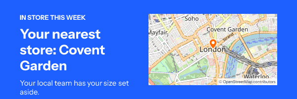
The usual way to get a map into an email is a screenshot: one place, one picture, out of date the day a store moves. A map layer is drawn instead. When a reader opens the email, the image service works out the centre, fetches the OpenStreetMap tiles that cover the box at your zoom level, stitches them, and puts your marker on top.
Because the centre is decided at open time, one template serves every store. A contact in Leeds sees the Leeds branch and a contact in Bristol sees Bristol, from two fields your platform already holds. The map sits in the same image as your headline and offer, so there is one image to place and one image to test.
Zoom runs from 2, a continent, to 18, a single street. Somewhere between 13 and 15 shows a neighbourhood with enough street names to be useful at phone size.
How to add a map to an email
-
Step 1
Start from "Find your nearest store"
The Gallery design has the map, a store name field in the headline and the two coordinate fields already wired. Or add a map layer to any design from the Add grid.
-
Step 2
Set the place and the zoom
Name the fixed place and give its latitude and longitude; it is also the fallback whenever no other location can be read. Pick a zoom and a marker colour.
-
Step 3
Choose where it centres
Leave it on the fixed place, centre on where the reader opened the email, or read a latitude and longitude, or a city name, from contact fields.
-
Step 4
Publish with a link
Set "Links to" in the editor to your store locator, then copy the snippet for your platform from the publish dialog and paste it into the email.
Where a map earns its place
Click and collect
The order is ready: show the store it is waiting at, from the store's coordinates on the order.
Events and open evenings
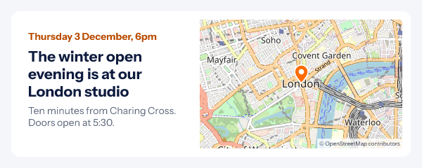
The venue in the invitation and again in the reminder, so nobody has to search for it on the day. Pair it with the weather widget for the forecast.
Local offers
A store opening or a local sale, centred on each contact's nearest branch, so one send serves a whole chain.
The map pictures on this page are the engine's own renders, drawn from OpenStreetMap tiles recorded for central London. For the email that carries them, read the event reminder email guide and the event registration campaign.
Which plan includes maps
Every plan, the free one included, for a fixed place and for where the reader opened the email. A centre from each contact's fields needs a signed image address per recipient, which comes from a recipient list or the API on Growth ($54 a month) and Agency.
Compare the plansWorks with your email platform
A map is an ordinary image tag with a link around it. These guides show where it goes in each platform and which fields it can read.
What a map in email cannot do
- It does not pan or zoom. It is a picture; the link around it opens the full map.
- One marker, at the centre. No routes, no several pins, no labels of your own on the map.
- No reader location behind Gmail's or Yahoo's proxy. Those opens show your fixed place. Use contact fields when the store has to be right for everyone.
- City names match places of 100,000 people or more. A smaller town falls back to the fixed place; coordinates always work.
- A tile that cannot be fetched is left plain. The rest of the image is drawn, and the next open tries again.
Map in email questions
Can I embed an interactive Google Map in an email?
No mail app runs an embedded map: scripts and iframes are stripped. What works everywhere is a map drawn as an image, wrapped in a link to the full map or your store page. That is what a map layer is.
Where do the map tiles come from?
From OpenStreetMap, the open map built by volunteers. Every map image carries the credit "© OpenStreetMap contributors" in its corner, and the marker is drawn by us in the colour you pick.
Can each contact see their own nearest store?
Yes. Set the layer to read contact fields: a latitude and a longitude, or a city name. The "Find your nearest store" design in the Gallery is set up this way, with a store name field for the headline.
Can the map show where the reader is?
It can centre on where the email was opened, rounded to about ten kilometres. Gmail and Yahoo fetch images through their own servers, so for those opens the map shows your fixed place instead.
Can people click the map?
The whole image can be a link, set in the editor’s "Links to" field, to your store locator or a directions page. Individual streets and pins inside the image are not separately clickable, because it is one picture.
Which plan do I need?
Maps are on every plan, including Free. Centring on each contact’s own fields needs a signed image address per recipient, which comes from a recipient list or the API on Growth and Agency.
More you can draw into an email
- Weather Widget The forecast for where each reader is.
- Calendars A month with your dates marked.
- Barcodes Code 128 and EAN-13, ready for the till.
The getting started guide covers publishing, and the merge tag reference shows how a contact's coordinates reach the image. Everything else an image can carry is in personalized images for email.
Every feature on one pageShow people where to go
Start from the store finder, set the place, paste one image. Free for 5,000 opens a month.